Bradley's View

Bradley's View

Friday, March 29, 2013

From The Mountains To The Sea

"There's a kind of luck that's not much more than being in the right place at the right time, a kind of inspiration that's not much more than doing the right thing in the right way, and both only really happen to you when you empty your heart of ambition, purpose, and plan; when you give yourself to the golden, fate-filled moment."
-A Character in the book I'm reading

     Our plans have formed slowly while time has moved quickly.  But here we are, at the end of a year's stay in the wild west.  I would like to talk more about the time I've spent here, but I think I will save that for the next post, as I have one wonderful exclamation point of an adventure still planned...  This post is for the future, which is the only direction I find good reason to explore today.

     My dear wife, Melissa, has received the opportunity to work for the North Carolina Aquarium in a position that meets the description of her "dream job".  It is incredibly inspiring to see doors swing wide open in response to someone's persistence and hard work.  I couldn't be more proud of her.

     Having said that, we will be taking leave of Colorado in less than two week's time in order to make our way to the Outer Banks.  Melissa will begin work, Luna and I will begin to walk.

    For the most part, plans regarding our walk have remained incredibly tentative.   The only thing that was certain that we would be out walking merrily about for at least 3 months.  The idea was birthed in light of dreams of hiking the AT.  As I brought that ambition into focus a little bit further I realized that it wasn't the novelty of being an AT-thru hiker, or meeting people on the trail, or sleeping in shelters that drew me towards the experience.  In fact, those things may be deterrents.

    My desire for this trip is to have a truly authentic experience, one that will be mine alone, unweighted by expectation and advice from others.  The best route would be a route of my choosing, one that features options and intersections such that I can roam and explore at my leisure.  I've decided to hike the Carolina Adventure Trek, we'll call it the CAT.

    Beginning at Adam's house, a couple of miles off the Mountains-To-Sea trail north of Asheville, I will walk south until I meet the Art Loeb Trail.  From the Art Loeb, I will follow the SAGE route in the clockwise direction through Brevard, to Caesar's Head State Park and the eastern terminus of the Foothills Trail.  The Foothills trail will be a peaceful and beautiful section of the hike; once it's 77 miles are completed I will be near to the southern terminus of the Bartram Trail at Ocone State Park, SC.  Hiking north on that I will, in about 100 miles, meet the AT near the summit of Cheoah Bald.  Following the AT south from there will bring me to Springer Mountain, GA in about a week, where I can begin hiking the Benton MacKaye Trail.  300 miles later, the trail will end in the Smokies leaving me poised to start the Mountains-To-Sea Trail atop Clingman's Dome and follow it roughly 930 miles across the state and up the coast to the trails end in Jockey's Ridge State Park, a couple of miles from Melissa's place of employment.  There you have it, the CAT!

     Executing this hike will embody more of the experience I desire than I may be able to find on the AT.  I will be able to go days without seeing anyone in certain sections, I will have the power to alter my route whenever and however I see fit, I will be accessible to family and friends, ensuring I'll be able to attend the high school graduation of my brother, Peter, and I'll be able to walk directly to my darling's doorstep.  I don't think I could ask for anything more...

     Here are some pictures of things that have occurred:


My brother, David, came out to visit.  We had a blast skiing and hiking.


We headed up towards Mt. Yale from the Denny Creek Trailhead.

Dramatic post-holing near treeline thwarted any ambitions of summiting we may have had.


It was a marvelous day, though.


Luna rested at the trailhead, while I wore a goofy hat.


Imaginary chess was played.

Good times were had.

Lately, we've spent a lot of time away from snow in Buena Vista.  Hiking and scrambling have become the norms.


Midland Hill is a great place to play.  Yesterday, Mel, Luna, and I hiked the 1.75ish miles/1,750 ft, to the summit.


The day prior, Luna and I ran to the top.  We then donned our packs and grabbed the trekking poles and hiked to the summit once again.

Friday, March 8, 2013

Moab


    We glanced at the weather forecast, it called for 65 and sunny for our weekend (Wed/Thurs).  A warm summer's day here in Leadville.  Off we went.  

     Niether Mel or myself had ever ventured to Moab, though we'd both heard and read our fair share about the wonders of the red rocks.  It was pretty clear to me that we could in no way pursue every arch, explore every canyon, follow each track left behind by a dinosaur(?!), but we could get a taste of the dessert.


    Our day started early Wednesday.  A little coffee and breakfast at Love Muffin, which I would highly recommend, and we were off.  

    Our first outing took us west about 10 miles from the town of Moab to the Corona Arch Trailhead.  The hike was great; unique, short, and accessible for many while still leading to an absolutely incredible place.

A step ladder for ascending the shelf on which the trail traverses.


The ladies and the arch


Huge

     A quick trip into Arches National Park felt like an obligation, almost.  Thats only because we had the dog along, otherwise the possibilities are endless in the area.  We were bound by the roads this time through.  The park encompasses a truly spectacular area of land.

     We sought a campsite up and east from town on Sand Flats Rd, home to mountain biking's infamous Slickrock Trail.  We picked a site, trying our best to find a suitable tree for blocking the wind.  Then we set off on the Slickrock Trail's Practice Loop for a fun run.

A nice view of the La Sal Mountains from the campsite

  
Follow the white blazes...


Luna admiring Negro Bill's Canyon (foreshadowing)
Me and Lu
     Lately Luna has really been a tough pup.  I'm glad she's my friend.   Check out this inspirational tale of a dude and a dog.

Rise and Shine.  Stretching it out at sunrise.
    Thursday, we followed Negro Bill's canyon back a couple of miles to Morning Glory Natural Bridge.  I enjoyed looking up towards the places we'd played and slept the day before.
Stream through the canyon.  Echo Point up at far left.


Morning Glory Natural Bridge
    Inspiration is everywhere.  I could never tire of life. 

    I'm also intrigued with the idea of doing canyoneering of some sorts:  Ideally, adventures could be designed that are done in the fastpack style, but feature ascents, downclimbs, and rappels that would require the use of a rope.  The intention would be to make large sweeping loops linking various canyons and otherwise unaccessible mesas.  I imagine that the inspirational melancholy of sitting alone atop a small mesa, looking out over the veins of the canyons that pump towards the life-giving rivers, would be second to none.


    This post will be the 100th since this blog was started nearly two and a half years ago.  I hope you have been able to take something positive away from at least one of these posts over that time.  


Tuesday, March 5, 2013

Desert Love


   Something I've been thinking about lately is the beauty of the fact that once we experience the humbling beauty of a place for the first time, it's kind of like falling in love, it enables us to better feel and recognize the beauty of other distinct places.   For example, I first experienced the overwhelmingly powerful magnificence of a landscape in Western North Carolina, where I grew up.  I was standing on top of some of the bald peaks looking with awe at one of the planet's oldest mountain ranges, I marveled at the contours of the ridges and the depth of the valleys,I felt the tremor of ancestors who had hugged the mighty rivers of the mountains through millennia and the people of the present who build cities around their very banks.  I breathed in every facet of the landscape. And I did it in one breath.  It got me high, you might say.  It was a sensory and emotional overload that can only be described as ineffable, beyond expression.  

      My senses and emotions were never the same.  They were enhanced tenfold, capable of registering beauty in nearly every square inch of the earth.  It didn't matter if it was a sandy flat on the bottom of the sea, or the flatlands of Western Kentucky.  I could see it.  I could feel it.  

     Coming to Colorado and playing in it's deserts and woods, I've experienced it again.  It has so inspired me that in nearly every moment I dream of exploring it's landscapes in an effort to bring description to that which is otherwise ineffable.

      That being said, I'm about to head to Moab to experience the red rock that inspired Everett Ruess to write these words:

"I am drunk with a searing intoxication that liquor could never bring--drunk with the fiery elixir of beauty, the destroying draught of power, and the soul-piercing inevitability of music. Often I am tortured to think that what I so deeply feel must always remain, for the most, unshared, uncommunicated. Yet, at least I have felt, have heard and seen and known, beauty that is inconceivable, that no words and no creative medium are able to convey. Knowing that the cards are stacked, and realized achievements are mere shadows of the dream, I still try to give some faint but tangible suggestion of what has burned without destroying me."

        Here are a few pictures from a couple of days around Little Dominguez Canyon last week with Mike and L.D:
View off towards Grand Mesa over Little Dominguez Canyon
Enjoying a nap in the warm sun after a cold night in the bottom of my sleeping bag.

Meandering on Steamboat Mesa

L.D and Mike at Little Dominguez intersection with Lightning Basin


Poor cow was right on the trail on the way back.
Where was he on the way out...
 

Saturday, February 23, 2013

Run Mountains, Feed People

Lately, snow has been the norm around here.

Last Monday, Luna and I broke trail up to Hope Pass

I recently had a pair of skate skis passed down to me, which has been great motivation to get out every day, I'm grateful for the gift.

A couple of nights ago Luna and I went to visit with Mike in Frisco.  We didn't get there until late, but that didn't stop us from heading up Mt. Royal in the dark and cold  you find above 10,000 ft at 11:00 at night.  Mike is about 125 summits into his goal of 365 summits of Mt. Royal.  His cause is noble and his motives are humble.  Check it out through the link above and consider making a donation, if you feel so compelled.  Thanks to the support of generous folks, the food bank in Frisco has accrued over 1,000 lbs of food for the hungry.


The turn-around point of yesterday's ski into Mayflower Gluch.
I probably won't do this route again on skate skis- it was tough.

Friday, February 15, 2013

Gear, Dominguez Canyon, Runs For Relief: New Hampshire

    We didn't hit the road till around 7, and after a few pitstops we reached the Bridgeport access to the Dominguez Canyon Wilderness Study Area around 10:45 PM.  It was dark and already cold.  I pitched the tent in the parking lot, fluffed up  the sleeping bags, and the three of us assumed the fetal position hoping to retain any bit of warmth we could.  Sleep was tough to come by.  Our sleeping bags, rated at 30 and 15 could do very little to shield off the 4 degree temperatures outside.

    We got up quickly at first light, boiled some water, ate some oats and a poptart apiece, decided it was against our best interest to brave another frigid night in the canyon, and headed out for a day-hike.

    .

I fashioned a dogfood can into an alcohol stove before heading out on the trip.  Using about 1 fl oz of denatured alcohol a pint of water begins boiling after about 6 minutes, 30 seconds, with another minute remaining until the alcohol burns out.


    I packed a good 25 pounds into the pack, just to get some proper practice and we set off.  We hugged the railroad tracks along the Gunnison River for the first mile and a half before crossing a bridge and weaving our way over towards Dominguez Canyon.  We spent the day hiking, lounging/napping in the sun, and examining the evidence of civilizations past, for whom the canyon served as a home.

     Enjoy the photos.

      I think next week I'm going to make my way out here (solo and with a warm sleeping bag), I have three days for hiking allotted and think I can dial in an 80ish mile loop, utilizing the North Uncompagre Wilderness and the Tabeguache trail, that would be great practice for the AT.

The tarptent set up without the interior/bugnet/floor.  Extremely lightweight, simple, requires only trekking poles and stakes.


House, built in 1901

Nature's dog house, built over hundreds of thousands of years


Wow

People on horseback.  Alligator snapping turtle??

Mel sitting by the frigid Big Dominguez Creek a few miles before it feeds into the Gunnison.
Home away from home.

Pulled one of these guys out of Luna's foot- ow.

Luna elected to cuddle next to some trekking poles for her afternoon snooze

Packdog

Gunnison River

Hitched a ride back to the trailhead

     Meanwhile, somewhere in the east, Rob has mapped out a feasible route for a run across New Hampshire for a second edition of our Runs For Relief project, which had it's first event in Rhode Island almost a year ago.  We're looking at a ~73 mile route and a late March execution date.  I hope that logistically I'll be able to formulate a way to get out there and join him in the effort!


Saturday, February 9, 2013

Training And Snowshoeing At The Vail Mountain Games

"Those with stronger wills 
will stand so still they 
grow their roots away from it
But oh to use those roots 
to feed the leaves that do 
indeed grow towards it.
Oh the space above our heads is useless 
unless we do reach for it.

Ain't it funny that all we have
Is all we know
And all I know is flight"
-PigPen


    The last week or so I've had occasion to really dial in my gear for the upcoming Appalachian Trail trek.  I've got a pack that packs just right, a great shelter that is both sturdy, light, and quick to set up and take down.  Most importantly I have a pair of strong, healthy legs that are adapting well to carrying a greater load at a reasonable pace.

     On Monday, Luna and I got dropped off at Turquoise Lake and completed a 7 mile stroll back to town while carrying about 28 lbs.  We completed the route in 1 hour 39 minutes and some seconds.  The route was a steady climb of about 550 ft, pretty trivial compared to the AT, but I was still delighted to maintain a pace of about 4.25 mph.

    Tuesday I had a little window in a long day of working that allowed Luna and I to get out for 31 minutes.  We ventured up the hills in the backyard for 2.1 miles and 500 ft of gain.  Despite the climbing and snow on this short outing, we were right around 4 mph once again.  Tuesday night, Mel, Luna, and I made it out for a nordic ski, which is always a pleasure; even more so on a clear, quiet night when the sky is speckled with stars.

    Thursday rolled around, I rolled out of bed.  I glanced at the thermometer and saw it was a whopping 5 degrees out, I then looked at the day's projected high in Boulder and saw that it was 55(?!), so we went there.  We hiked a 3 mile loop from Chataquah  Park (carrying ~25 lbs), scrambled about halfway up the second Flatiron (not Luna's favorite activity), and headed back home.


     When we got back to Leadville, there was a package on our doorstep.  Inside the package was our Tarptent Stratospire II.  I tossed it in the pack (~18 lbs), grabbed the poles, strapped Luna's pack on and went out to try my hand at setting it up.  It was dark, snowy, and cold; I figured if I learned to set up the tent for the 1st time in the dark it would be good preparation for the AT, where I expect to be setting up the tent at night frequently after long days of hiking.  I'm not sure how long it took me to set up the tent, but it couldn't have been very long as our trip was 3.15 miles in 58 minutes (including set-up/break-down time).

     The Stratospire II is a really cool structure that I look forward to really getting out in the field: I'll review it more throughly once I come to know it better.


     I worked Friday morning and, just after my shift, received a proposition to catch a ride up to the Vail Winter Mountain Games to participate in a snowshoe race.  I was really on the fence about it, with the possibility of a storm blowing in and making for a tedious drive back home, but after glancing at the website and realizing that 1) Snow is cool, 2) Snow is cooler when you're racing in it at night, and 3) I could race the 5k event with Luna, there was really no question.

    Around 3:30 Sage and Sandi pulled up, picked us up, and we made our way up to Vail, enjoying the snowy scenery.  Notch Mountain, neighbor to Holy Cross, looked absolutely incredible rising from the valley.

    We parked, picked up our packets, and hurried to get to the startline.  Sage and Sandi took off with the 10k start, and Luna and I waited for the dog wave, which started about 20 seconds after the 5k human wave.

     We bolted past as many folks as we could through the chute and had ample breathing room to settle into a groove on the first loop.  Luna was a good sport; she sported her Ruffware harness that she'll be wearing on the AT.  

      Snowshoeing is hard work.  We ended up finishing 1st among the dogs, and 2nd overall in the 5k, though.  

      Meanwhile, Sage and Sandi grunted it out over some grueling climbs and twice the distance against stiff competition to finish very well, 3rd male and 5th female, respectively.

     The atmosphere they create at the Vail Mountain Games is truly exceptional.  There are a lot of people working really hard both in the events and behind the scenes, it is a truly beautiful thing.


      These guys (Pigpen Theatre Co.) are doing really cool things, check them out: 


Thursday, January 24, 2013

Visit To Elbert And The Frenasco Fiasco


Those who contemplate the beauty of the earth find reserves of strength that will endure as long as life lasts.
- Rachel Carson

    The weather has been crazy; no snow for weeks, sunshine for days.  I fear for summer wildfires, the Front Range draining the remainder of our lakes, and all that but, man, I do love running in the mountains.

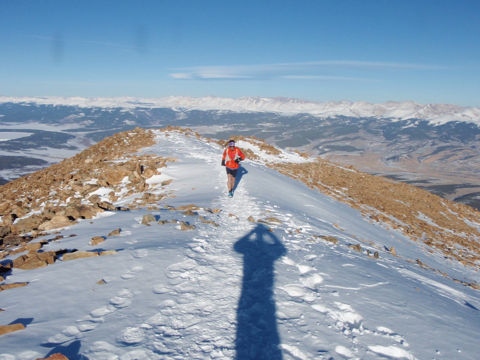
         Fortunately for me, so do Mike and Luna.  We went up Elbert last Saturday, settling for a 2:00 start and excited to be racing the sun.  As expected, it was snowy beneath the pines.  Once we got above treeline, we were able to move a lot more efficiently.  Being so late in the day, the southeast ridge cast shadows over our route and left us cold for about 40 minutes before welcoming the sun once again on the ridge.  We reached the summit in a minute or two over 2 hours, and made it back to the car a minute or two before 3 hours.  We ran really fast on the way down the ridge, it was sick.


Ridge to the summit

S. Elbert and La Plata in the background

Tried to fly and got denied


     The picture above leads me into my next outing.  The mountain on the right there is French Mountain (13,960 ft), the ridge runs west then south cresting Frasco(just barely in the light), and Casco(prominent in left of frame), as well.  I see these peaks from my window every morning, as they shoot out of the valley between Elbert and Massive.

     Anyways, the route, we'll call it the Frenasco, made for quite the fiasco.  My starting point was at the Mt. Massive TH.  I began by skiing about 2 miles up the road to the junction with FR 110.J, continued skiing up this road until it because unreasonably steep, which was about another mile.  It was my belief that the choice to ski would greatly enhance the fun-factor, in reality though, the snow sucked for the first couple of miles and was so deep and so steep in the next mile it was never all that great.  In fact, I quickly realized that it would be far more beneficial to have snowshoes.  
Fresh Tracks

Icy Paths
     I carried on up the road towards Iron Mike Mine.   The snow was just below my knees for the entire slog.  It was slow moving...

The basin begins opening up

      I contemplated the ideal route to French's summit, but acted rashly instead of seizing it.  Ideally, I would have continued up the gulch to Iron Mike Mine, which was probably about a mile away, but really the going was so slow that every extra mile up the basin was one more I'd have to walk down.  So I had hoped to summit via French's east slopes, and return down the ridge to my skis.  

Elbert's slopes looked far more appealing than my route
     Gaining vertical was incredibly tedious.  I was keen on the prospect of utilizing rocks versus snow in the ascent after what I'd been up to the last couple of hours.  The rock route proved interesting, as each piece of talus was surrounded by a couple of feet of snow, making any misstep a bit frustrating (particularly for the pup).

Rock hoppin'
      We got up to 12,500 ft when I decided to turn around.  I think the ideal equation for this approach would be today+one human+two snowshoes-one dog.  Sorry for a crumby day, Luna.

       I was able to run a little bit through the powder on the way down, reached the skis and began to ski.  The route was about 12 miles total and took me about 4 hours.  I've got to get out here again, and look forward to completing this line and extending it over Elbert's summit.