Bradley's View

Bradley's View

Tuesday, June 25, 2013

Up

     It's been a while since I posted anything on here, but it isn't because I haven't been doing anything...  After hiking, I headed out to the Outer Banks to spend some time with Melissa, where I familiarized myself with surfing, read lots of good books, and worked at a coffeeshop briefly.  
     Shortly thereafter, I received a proposition to return to Leadville and resume my role at City On A Hill Coffee & Espresso.  I thought of Colorado summers, exciting happenings in the coffee business, and the general peace of mind equated with a low-key low-maintenence low-income area like Leadville, and that was that. 
     I got back to Leadville two weeks ago.  It's felt a bit like picking up where last summer left off.  The summits make me feel alive.  I run ridges and smile so much that my face hurts.  
     I foresee a lot of high peaks in the future.  But, right now, I am sitting in the Denver Airport (my flight is delayed) getting ready to fly to Minnesota for a 10 day paddling trip in Quetico Provincial Park.
      
      Meanwhile, Matt is putting up an incredible effort on his <60 day AT-hike.  

The Three Apostles, seen from Mt. Huron's southern ridge.


Jason ascending Kelso Ridge

Kelso Ridge

Kelso Ridge

View of Torrey's from near Gray's summit.


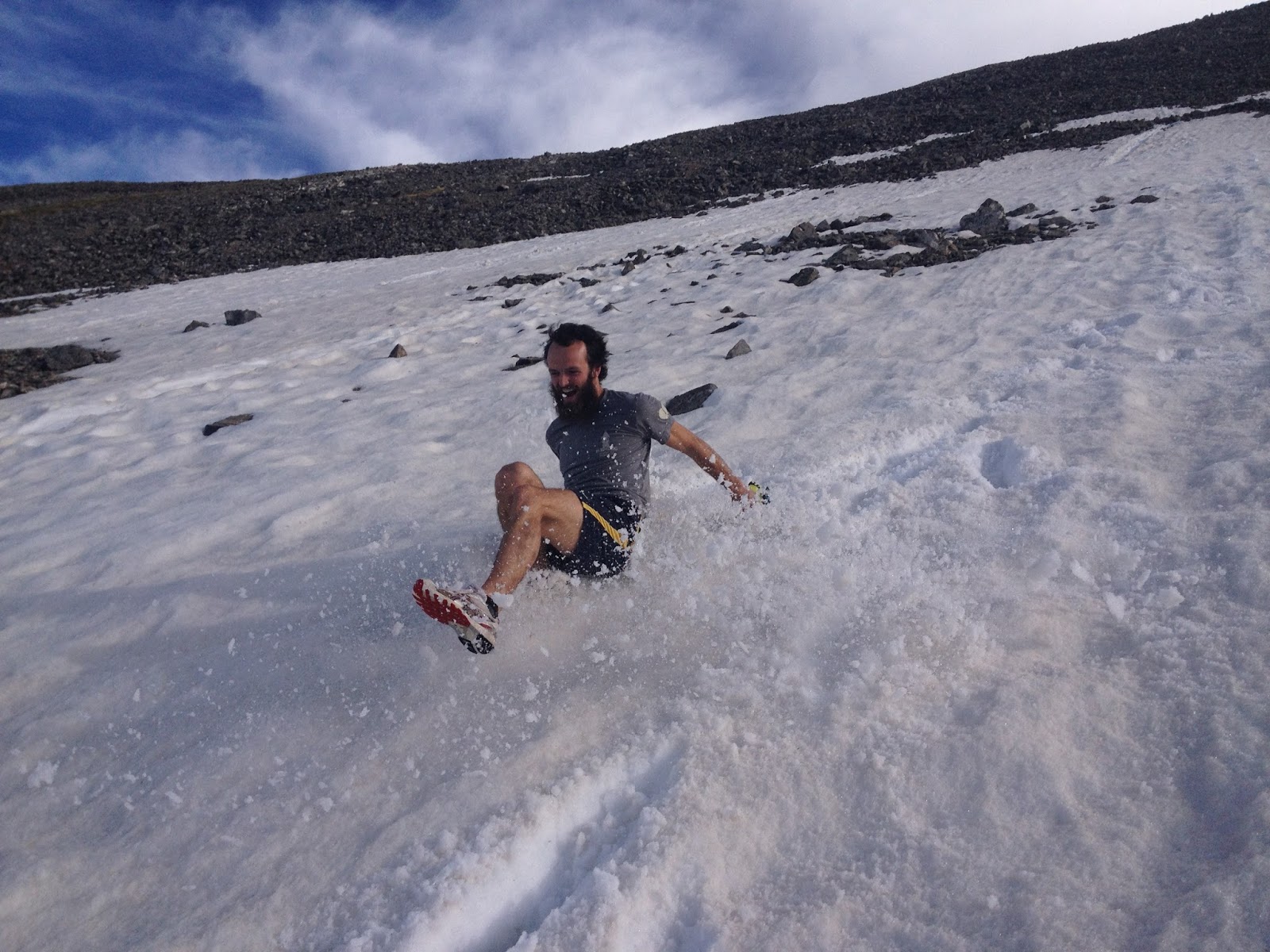
Preparing to glissade.

Yeah.(Photo J.Antin)


Goat.
Photos: J.Antin


Tuesday, May 21, 2013

Foothills Trail Fastpack


    Adventures don't always end up as planned.  If they did, I would likely refer to them as activities.  I once heard someone say that adventure doesn't begin until something goes awry.

    Luna and I reached the Casa de Kirk and decided to layover a few days in celebration of Lily's birthday.  We played board games, harvested ramps, and spent a day paddling on the French Broad; time well spent by any measure!  After the paddling trip, we elected to hitch a ride with Eliot and Ashley to their house in Jones Gap State Park (SC).  This allowed us to shave about 14 miles of roadwalking that would have been less than enjoyable, especially with the four-legged one.
Luna and Uwharrie conked out.

    So the story begins at Jones Gap State Park, the eastern terminus of the blue-blaze spur of the Foothills Trail.  What follows are my journal entries, so forgive any lack of eloquence, I was typically tired when I wrote them.

Saturday, May 11, 2013

Hiking Trip/Tracking The Trek

    A couple of days ago Luna and I set off from Asheville bound for Brevard.  The first day of hiking was beautiful and enjoyable as we rode the Mountains-To-Sea trail across Asheville.  We hiked for about 8.5 hours, covered about 30 miles, and camped atop Ferrin Knob.
    On the second day we started with the sun and continued climbing the remainder of the Shut-In Trail en route to the Pisgah Inn.  We relaxed at the inn for a couple of hours and enjoyed a hearty breakfast and began our descent through the Pisgah Ranger District at about 11:30.  The water was really flowing due to all the recent rain, and creeks were turned into cascades.  We trudged down the MST to the Barnett Branch trail, crossed the South Fork Mills River, and climbed up to the Black Mountain Trail.  At about 3:00 we arrived at the Buckhorn Gap Shelter with intentions of settling in there for the night.  By 4:00 I had woken up from a siesta, realized that there were still 4+ hours of daylight, and elected to continue hiking.  Quick climbs up Clawhammer and Black Mountain led to a lengthy descent down to the Davidson River.  The Brevard Bike Path then took us into town where Matt met us and directed us to a crucial side trail linking us to the Oscar Blues Brewery.
    A run up Bracken Mountain, the celebration of Lily's birthday, and all around good company have led to a good couple of days of R&R here at the Casa de Kirk.

Sunrise from Ferrin Knob

Morning light near Big Ridge Overlook

Near the Pisgah Inn

A bee pollinating Trillium

Clouds coming in seen  from the saddle of Clawhammer and Black Mountain

Refreshing in the Davidson near the day's end.

    Monday morning we will take to the woods once more.  Our final destination on this 450 mile journey will be Roan Mountain, and we must be there by May 30th (for the RAM). Below is a map on which our progress will be recorded, if you find yourself interested in following along.


Monday, April 15, 2013

Linville Gorge Marathon


      36 hours in the car was plenty.  We stretched our legs with an overnight stay at the Chateau du Hill, in Asheville.  The rain had followed us for the final 12 hours of our drive; Asheville received two inches.  We arrived in the darkness of both the clouds and the night.  When morning came, the greens were overwhelming.  The earth had bided it's time; the laughter of thunder had roared in it's face, the moon, on it's last waning leg, had disappeared from the sky at an early hour, passing it's domain to the rule of the unruly clouds, who lashed out at every uncovered inch of the earth with torrents of tears.  Hours of soaking had primed the earth and for every hour of light the green of it's glory shone, a stark contrast to the bleakness of the night before.  Trillium and Bloodroot burst forth, rearing their heads in communion with the sun, their annual tradition had arrived after a brief rain delay.  The dance of spring had begun.

       Our arrival to the east could scarcely have been more timely.  For one, in the past two days our home in the high-rockies has received two feet of snow.  This far along in April, I prefer the smells of spring.    Secondly, this past weekend marked the third annual running of the WNC Trailrunner's Linville Gorge Madness Marathon, which is where this story continues.

      The route, designed by Brandon, is one of the least contrived and most grueling marathons yet conceived in this country.  It runs about 27 miles and features some 9,500 ft of vertical gain.  It is hot, exceedingly beautiful, and doesn't run the same trail twice.

      An exchange that is telling of the course:
 
      Me:  Hey, can I see that map... Oh, I think I'm going on that trail.
      Guy With Map:  Probably not, no one really uses that trail, it's covered in fallen trees and drops quickly to the river...
      Me:  Yep, definitely the one.

      Anyways, we arrived at Table Rock Friday evening, pitched tents, burned sticks, and enjoyed beer with conversation.  It was great to share the evening and the run with people I hadn't seen in at least a year, and some others that were new to the WNC Trailrunner community.
The crew on Table Rock.  Photo: WNC Trailruners

Table Rock from it's namesake parking area.  Photo: WNC Trailrunners

    The Linville Gorge is the largest canyon east of the Mississippi; it was pretty wild to think that only a week before I had been in the depths of the Grand Canyon.  My intentions had been to hike the route with my backpacking gear and trekking poles.  It would be practical training, and I don't think I've run more than 9 miles in one outing since the Zion Traverse back in November(?!), but I was swayed towards running by a desire to share strides with great friends.
Photo: WNC Trailrunners

      At 8:30 we began the mile long hike up to the summit of Table Rock, snapped a photo, admired the sweeping panoramas, and then set off.  Little Table Rock Trail descended about 1,000 feet over the first mile.  The rhododendron rafters served as handholds as we skipped and swung our way down to the Spencer Ridge Trail, which clicked off the next 1,000 feet into the gullet of the gorge, where the Linville River sliced swiftly down to the lowcountry.

Table Rock in the distance.  Photo: WNC Trailrunners
      After following the river for a few miles, bobbing up and down it's banks and hearing it's rumble, we ascended the switchbacks to the western rim of the gorge and followed a jeep road for a couple of miles to where Melissa and Hannah had generously laid out a few gallons of water with which we could fill our bottles.
Gorge-ous.  Photo: WNC Trailrunners

      We pranced down Connelly Cove to the Rock Jock Trail, which is absolutely spectacular.  It isn't maintained and made for more of a steeplechase than a trail run.  For three miles we followed it along the canyon's rim before a steep climb brought us back to the main forest road.  Adam caught up at the aid stop before a three mile stretch of forest road and we busted out the 5k in about 20 minutes, which gave my three-month-taper quads a bit of punishment.  We relished in the view from the top of Pinnacle Mountain, then plummeted on another absurdly steep descent along the Mountains-To-Sea Trail to the river.

      On the trail we were greeted by the whirring hiss of a Cottonmouth.  It coiled itself, showed off its venomous fangs, and made wide it's throat urging us to pass quickly without any unnecessary molestation.  The MST then crossed the river, which rose to our waists.  The thirty yard crossing was incredibly refreshing, especially to my quads, which were feeling quite battered from the quick clip and heavy descents.

Linville River.  Photo: WNC Trailrunners

Black Mountains in the distance. Photo: WNC Trailrunners
      Dave and Brandon joined us for splashing in the river and we set off up Shortoff Mountain.  The trail up Shortoff was sensational, we had an incredible view of the terrain we'd covered and the Black Mountains and the South Mountains in the distance as we weaved our way through the mountainside that had been scorched by a wildfire in '97.  It felt like another world.  The climb was tough, but so were we.

      We added one to our party at the spring on Shortoff, refilled our bottles, and settled in for the final 6ish miles.  It was a sensational stretch of running.  The final 900 ft ascent to the Chimney's was awesome.  It hurt, but in a way that you can appreciate, if that makes sense... We weaved through the rock formations speckled with climbers, and made our way back to the parking lot after about 6 hours and 53 minutes out in the sun.  Laughter ensued.
Photo: WNC Trailrunners

Photo: WNC Trailrunners

      I really look forward to spending more time in the Linville Gorge area on my imminent backpacking adventure.  It's a truly special place, that I was glad to see so many people out enjoying on a beautiful Saturday.

      Thanks for reading, now go play outside!
    

Sunday, April 7, 2013

Additional R2R2R Photos

All of the following photos were taken by Ryan Kirsch on our overnight R2r2r excursion.


Una lagartija;
it's toil is nothing more than the pursuit of sunshine and the unending performance of push-ups

A Kaibab Squirrel, endemic to the north rim

The North Kaibab Trail

Me, trekking up the North Kaibab

The view from our campsite by night.


Me and Mike, he's only got about a mile of running to reach the north rim at this point.

Me, marching like an ant.


Friday, April 5, 2013

Grand Canyon: Renegade R2R2R


             Before I begin, I should probably define a few things: R2R2R= Rim to rim to rim, it refers to a double traverse of the Grand Canyon.  The route we planned on taking would be about 46 miles with about 11,000 ft of vertical gain.  Renegade= one who defies social norms or conventional behavior.  This is not your average trip to the Grand Canyon.
            We left Leadville later than we’d hoped, around 11pm.  We creeped slowly at first due to a snowstorm.  Everyone was weary from their respective days, but a buzz of excitement gave life and energy to the snugly spacious truck.
            We took our turns driving; gripping the wheel, adjusting the a/c, watching for deer, and humming along to music until our eyes gave out.  Then it was on to the next person.  Sleep was hard to come by.  I probably got 3 or 4 hours, at most.  We passed by Durango, the Four Corners, and Everett Ruess’ beloved Kayenta, before the sun rose.  In our insomnia-induced delirium, we laughed and chatted as Jerry Garcia encouraged us to keep “Truckin’” on the final approach to the park.

Ryan, Jamie, and Mike upon arrival at the park.
            A visit to the backcountry office in hopes of obtaining overnight permits bore no fruit, which meant Ryan and I would have to push as deeply into the canyon as we could in the afternoon; far away from the crowds, the laws, and the luxuries.  We were bandits whose cash and jewels were the experience of a lifetime, our horses were our legs, and our guns were nothing more than smiles, positive words, and dastardly good looks.
            Starting after 11am was less than ideal, but our need to cover ground left us with little time to contemplate our circumstances.  On the initial descent of the Bright Angel Trail, we felt like asses.  Really though, we weren’t so different from the burros, who left their corrals on the South Rim just to be herded into the bottleneck of the canyon’s switchbacks.  For the first mile we may have passed a dozen people every switchback.
View from early in the descent of Bright Angel Trail.
            I found it easy, at first, to resent the crowds.  But in the midst of both forlorn faces and confident children, I began to marvel at the situation.  I contemplated the success of this particular National Park; it’s campgrounds are booked nearly all year, to the point that some reservations must be made over a year in advance.  It speaks for the beauty of the place, really, that so many people are willing to push themselves physically and mentally in a way they never have all in pursuit of coming to know the canyon and bearing witness to it’s awe-inspiring form.
Bright Angel Trail
            As we wound down into the ditch, the greens became vibrant, and purple and red flowers projected a new aura of life in the landscape.  Spring was in the air at Indian Gardens Campground.  The sun, however, was ready for summer.  Searing our faces, the sun lashed out it’s warnings.  Nowhere does one feel so safe in the shadows as  in a canyon.
            The descent wore on and the crowds wore thin.  Then, we were greeted by the roar of the mighty Colorado.  The waters were painted brown from hundreds of miles of travel and moved with a graceful maliciousness.
The Colorado River
            We re-upped our water supply at Phantom Ranch and settled, snacking in the shade, to let the worst of the sun’s wrath pass us by before moving on.  In moving beyond the bustling canyon community, we also moved beyond the average soul's threshold for adventure.  The trail was ours alone, though a multitude of lizards scurried about.  They hoped to stake their claim on any sunny section they could find.  Shaded in the Inner Canyon, we moved with ease, never falling more than a step off pace.

Many bridge are used to navigate the canyon without disturbing Bright Angel Creek
            A couple of hours of hugging the creek moved by like a dream; every corner we turned unveiled another distant spire looming up to a mile overhead.  They stood like torches, bright red at the tops in the fading sun.  Our appetites were heavy in tow when we arrived at the Cottonwood Campground.  We refueled, spotted an empty campsite, and kicked our feet up.
            The night was warm and still, and the stars outlined the canyon’s rim.  We had covered 16 miles over the course of about 7 hours, including some substantial breaks.  We were 7 miles and 4,200 ft from the North Rim, and we were tired.  Tired from the drive, the lack of sleep, the sun, and the packs on our backs.  We slept soundly, smiling.   We rose at 5:30, barefoot and shirtless in the cool morning air.  We snacked briefly, laughed about the 30 mile day we were about to begin, filled our water and set off.  A couple of miles later we had some more breakfast in the face of Roaring Falls.  We hiked at a strong clip, giving due time to the snapping of photographs, and the general marveling at scenery that is impossible not to do on that trail.  The Supai Tunnel, 1.7 miles from the top, had collapsed in the past year since I’d been there.  The ecosystem shifted dramatically in the ascent.  The cacti relinquished their reign, giving way to the towering pines and aspens, majestic on the soft forest floor.

Hiking up from Roaring Falls


Ryan, arriving at the North Rim's trailhead
It was so still.  It was just as I’d left it a year before.  The same sounds predominated the plateau; the needles of the ponderosas chattered in the gentle breeze, the endemic Kaibab squirrels scurried and soared between tree branches providing the erratic percussive rhythm, which called to mind reminders of spring despite the presence of the snow.  The forest road that connects the North Rim to the rest of the world is closed in April.  The solitude is an incredible contrast to the hustle and bustle of the South Rim and it’s trails.   7 miles were done for the day and 23 remained.
We took our shirts off, kicked our feet up, and enjoyed snacks for a half hour or more.  A man from Lake Tahoe paused his run at the trailhead as well, we shared chit-chat, uncovered a couple of mutual friends, and said our farewells.  Though we had a long way to go, we were in incredibly high spirits.  You find it is hard not to be when surrounded by such otherwise unfathomable grandeur.  A little ways up from the Supai Tunnel, Mike and Jamie made their appearance.  The wear of the sun had started to show a little bit on their skin, but their smiles shined brighter still.  Over the next couple of miles, we passed three other folks out for R2R2Rs, two of whom were sure to have a very long day. 
N. Kaibab Trail
Redwall Bridge, N. Kaibab Trail
Ryan and I had a great time coming down, speculating on the engineering feats involved in the construction of the North Kaibab Trail back in the 1920s.  The trail is nothing but switchbacks, short and long, built into the walls of Roaring Spring Canyon, and one picturesque bridge leaping the depths of the gorge.

Ryan (lower left) on the N. Kaibab Trail

Tunnels of Juniper and Pines welcomed us back to Roaring Falls, which plummets dramatically out of the wall of the canyon into the junction with Bright Angel Creek.  We were moving well when we reached the campsite we’d left nearly six hours prior.  We loaded the tent and our sleeping bags we had stowed away back into the packs and settled in for another round of snacking, you can never do too much snacking if you’re hiking for the long-haul.
At 12:10 we donned the packs again and got our feet moving.  We looked over our shoulders all the while for Jamie and Mike to come bounding down the trail.  The heat was heavy.  It neared 95, I’m sure, but the breeze helped ease the pain.  When you’re running long and hard a little too much heat at the long time can really put a stick in your spokes.  The walls of the canyons rose higher and closed in tighter.  The shade was prolonged when it came, and it graced us with its presence more frequently.  The refreshment of the wind in our faces motivated us forward more effectively than if it had been in our backs.  We began to see day hikers by the dozen, Phantom Ranch was approaching.  In the heat of the day, the place was silent; I thought it a quintessential scene of the wild west: the bully comes to town, people run indoors seeking cover, peering out from their shades desperately wanting to witness the spectacle while keeping their safe distance.  Only in this case, it wasn’t some bad man with a caravan of robbers, it was Mother Nature.
Ryan, canyon creeping

It was a bit after two, later in the day than we had hoped to cross the river, but we were there.  There were others, too, far less prepared, who were yet to begin their late afternoon hike and were destined for the darkness. 
Mike and Jamie arrived shortly after us.  The heat had been unkind, and the experience unforgettable.  Mike took off up the trail, while Jamie elected to stay in our company for the ascent of the Bright Angel Trail.
We crossed the bridge and headed west along the Colorado for a taxing couple of miles.  I played a game on the dusty track; I followed Mike’s fresh and distinctive footprints in a light gait, attempting to emulate his every maneuver over rocks and around bends.  It kept me thoroughly entertained for about ten minutes as I marveled in how similarly Mike and I approached the dance of trailrunning.
A gentleman, maybe in his 70s, was walking east to the Bright Angel Campground.  The sun and sand had taken their toll, we wanted to keep moving, but couldn’t resist a cordial ‘hello’ in what may have been the least amicable exchange I engaged in all trip.
“Great day to be out here, isn’t it!”, I said
“Oh, absolutely.  Did you guys take a swim in the river?”, he replied.  We grunted a collective ‘no’.  None of the four of us broke stride for more than a second.
Another ten minutes passed and we looked at each other, discussed briefly, and decided that the man we’d all but ignored was really on to something.  Into the river we went, walking on the softest sand, as deep as we each dared to go.  I looked up at the canyon walls.  I imagined myself as a speck on a map of great scale, a little dot in the middle of an unparalleled geological phenomena.  I thought of the impossibility of it all.  I laughed and grinned with enough force to nearly split my sunworn lips right down the middle.
We slipped our feet, which had been dried quickly by the sun, back into our shoes and our backs back into our packs.  We passed many people, who, judging by their pace, would likely be spending a couple of hours hiking by starlight before it was all said and done.  We made it to the Indian Garden Campground, another water stop, 4.6 miles and 3,000 ft to the summit from there.  I felt like I had a score to settle with the sun; after it’s incessant torment the past two days in the canyon corridors, it was trying to escape at the time that I most desired it.  I hiked hard. I wanted to catch the sun, look at it as it disappeared, and plea to receive it’s respect. 
I bid adieu to Jamie and Ryan at the watering hole and began the final push up to the top.  I was in the zone, really.  I did the four-legged dance, each stroke and setting of my trekking poles was deliberate and efficient.  My legs churned and burned.  My heartrate elevated and settled to the pulse I was familiar with from the 100,000 feet worth of 14ers I’d ascended in the past year.  It is a very happy place for me, an intense kinetic meditation that drains me and fills me unlike anything else.
I reached the 3 mile marker and set a goal: 1 hour to the top. All the while, I knew if I could do it in 54 minutes, I would have completed my 30 mile day in under 12 hours, which would be gratifying, though fleeting in the big scheme of things.
When it came time to pass people, I lowered my heartrate to an effective level for conversing, and attempted to engage briefly with everyone.  In between passerbys, I moved up the canyon walls like a four-legged spider hoping to weave a web between these people, binding them by their common experiences in this place of bewildering beauty.
I got to the top.  I cried at the splendor of my circumstances and that place; to be so humbled and made to feel so small can be as painful as it is special.  But sometimes, in those moments, you feel like you’re just small enough to fit in somewhere in this wild world.
I checked the clock, it was 6:10. I glanced at the sun, maybe it acknowledged me.  Mike and Little Debbie met me (yes, the snacks).  We exchanged stories of our final hours in the canyon since we’d last seen each other, and sought out a perch by the rim.  Several switchbacks below we saw Ryan and Jamie, like heroes to us in the setting sun.  Ryan came at the canyon with only trivial training in the preceding months, but brought enough enthusiasm for the endeavor to fuel his mind and spirit if his body were to fail.  Jamie completed her longest run to date- nearly doubled it, on grueling terrain.  She felt a low she’d never felt and overcame it gracefully.  Mike did what Mike does; the dude is tough, but not calloused.  I have a lot of respect for these people and delight in their friendship.
Mike sits trying to take it all in after a successful R2R2R run
A meal at the resort’s lodge brought us back to the harsh realities of the National Park System.  People buzzed about the rim’s hive of life, most seemed cranky either because they were tired of being with their families, tired of hiking, or both.  The food was far better in our mind’s eye.
We began driving around 10:00 PM.  11 hours later, and a few states away, another renegade run was completed.

The Grand Canyon is, to me, the most magnificent place in the world.  Perhaps there will be another that moves me in that way, maybe not; but I intend to find out.  Whenever I find myself in a place of astounding beauty, my mind always wanders to thoughts of my family and friends that I love most and how badly I wish to experience with them. 

Friday, March 29, 2013

From The Mountains To The Sea

"There's a kind of luck that's not much more than being in the right place at the right time, a kind of inspiration that's not much more than doing the right thing in the right way, and both only really happen to you when you empty your heart of ambition, purpose, and plan; when you give yourself to the golden, fate-filled moment."
-A Character in the book I'm reading

     Our plans have formed slowly while time has moved quickly.  But here we are, at the end of a year's stay in the wild west.  I would like to talk more about the time I've spent here, but I think I will save that for the next post, as I have one wonderful exclamation point of an adventure still planned...  This post is for the future, which is the only direction I find good reason to explore today.

     My dear wife, Melissa, has received the opportunity to work for the North Carolina Aquarium in a position that meets the description of her "dream job".  It is incredibly inspiring to see doors swing wide open in response to someone's persistence and hard work.  I couldn't be more proud of her.

     Having said that, we will be taking leave of Colorado in less than two week's time in order to make our way to the Outer Banks.  Melissa will begin work, Luna and I will begin to walk.

    For the most part, plans regarding our walk have remained incredibly tentative.   The only thing that was certain that we would be out walking merrily about for at least 3 months.  The idea was birthed in light of dreams of hiking the AT.  As I brought that ambition into focus a little bit further I realized that it wasn't the novelty of being an AT-thru hiker, or meeting people on the trail, or sleeping in shelters that drew me towards the experience.  In fact, those things may be deterrents.

    My desire for this trip is to have a truly authentic experience, one that will be mine alone, unweighted by expectation and advice from others.  The best route would be a route of my choosing, one that features options and intersections such that I can roam and explore at my leisure.  I've decided to hike the Carolina Adventure Trek, we'll call it the CAT.

    Beginning at Adam's house, a couple of miles off the Mountains-To-Sea trail north of Asheville, I will walk south until I meet the Art Loeb Trail.  From the Art Loeb, I will follow the SAGE route in the clockwise direction through Brevard, to Caesar's Head State Park and the eastern terminus of the Foothills Trail.  The Foothills trail will be a peaceful and beautiful section of the hike; once it's 77 miles are completed I will be near to the southern terminus of the Bartram Trail at Ocone State Park, SC.  Hiking north on that I will, in about 100 miles, meet the AT near the summit of Cheoah Bald.  Following the AT south from there will bring me to Springer Mountain, GA in about a week, where I can begin hiking the Benton MacKaye Trail.  300 miles later, the trail will end in the Smokies leaving me poised to start the Mountains-To-Sea Trail atop Clingman's Dome and follow it roughly 930 miles across the state and up the coast to the trails end in Jockey's Ridge State Park, a couple of miles from Melissa's place of employment.  There you have it, the CAT!

     Executing this hike will embody more of the experience I desire than I may be able to find on the AT.  I will be able to go days without seeing anyone in certain sections, I will have the power to alter my route whenever and however I see fit, I will be accessible to family and friends, ensuring I'll be able to attend the high school graduation of my brother, Peter, and I'll be able to walk directly to my darling's doorstep.  I don't think I could ask for anything more...

     Here are some pictures of things that have occurred:


My brother, David, came out to visit.  We had a blast skiing and hiking.


We headed up towards Mt. Yale from the Denny Creek Trailhead.

Dramatic post-holing near treeline thwarted any ambitions of summiting we may have had.


It was a marvelous day, though.


Luna rested at the trailhead, while I wore a goofy hat.


Imaginary chess was played.

Good times were had.

Lately, we've spent a lot of time away from snow in Buena Vista.  Hiking and scrambling have become the norms.


Midland Hill is a great place to play.  Yesterday, Mel, Luna, and I hiked the 1.75ish miles/1,750 ft, to the summit.


The day prior, Luna and I ran to the top.  We then donned our packs and grabbed the trekking poles and hiked to the summit once again.